Ocean Currents Simulation
Grades 6–8 · MS-ESS2-6
Drop real ocean water into the Atlantic, turn on the wind, and follow the currents around the globe.

Lab controls
Views
More activities
Share & teachers
scisim.org/sims/earth-space/ocean_currents
Students scan it with a phone or tablet camera.
Ocean Currents lesson plan
Students will
- Explain how temperature and salinity change the density of sea water and drive deep currents.
- Describe how wind and the Coriolis effect drive and turn surface currents.
- Use evidence to explain how ocean currents affect coastal climate.
Lesson
5 min · Hook: the globe and Greenland water
Ask: Watch the intro. Cold, salty water near Greenland is dropped in: will it float, stop midway or sink to the bottom?
Expected answer
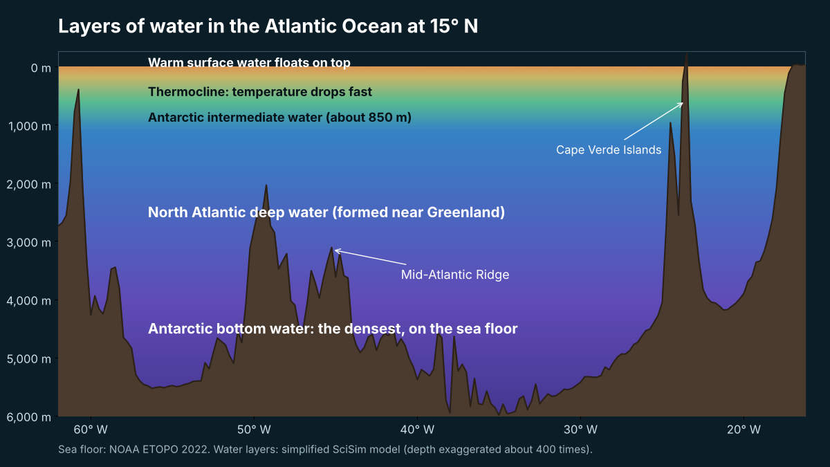
It stops at about 2,570 m, above the even denser Antarctic bottom water.
12 min · Deep currents (pairs): activity 1
Ask: Run all four water masses. What decides where each one stops?
Expected answer
Density at that depth: a sample sinks until the water around it is just as dense. Tropical water floats, Antarctic intermediate stops near 850 m, Antarctic bottom water reaches the floor.
10 min · Surface currents + map
Ask: Wind blows east: which way does the water go in each hemisphere? Then find two warm and two cold currents on the Globe.
Expected answer
Right of the wind in the north, left in the south, straight at the equator; red = warm (Gulf Stream), blue = cold (Labrador, California).
13 min · Rescue at sea (pairs): activity 2
Ask: Predict where the lost boat drifts, run it on the Globe and read the Drift distance graph.
Expected answer
Northeast with the Gulf Stream, then slowly with the North Atlantic Current to off Ireland (about 245 days in the lab).
5 min · Exit ticket (CER)
Ask: How does this warm current change the climate of the coast it flows toward? Claim, evidence, reasoning.
Expected answer
It makes winters milder: warm water gives heat to the air and westerly winds carry it inland (London about 5 °C vs Labrador about −14 °C in January).
What each part does
- Deep currents / Surface currents
- Two labs in one card: density-driven sinking, and wind, Coriolis and drifting boats at the surface.
- Water chips
- Real water masses with their temperature and salinity; My own mix opens the sliders. In Surface currents: three wind places and two lost boats.
- 3D | Globe | 2D
- 3D: the North Atlantic from real sea-floor data (NOAA ETOPO 2022). Globe: warm and cold currents and the conveyor belt. 2D: the same ideas without 3D.
- Predict and Run
- Students commit to a prediction first; the Result box shows the verdict, the evidence and why.
- Graph
- Depth, density, density vs depth profile, drift distance, temperature along the path, before / after.
Activity answers
Where does Greenland water go?
Rescue at sea: where did the boat drift?
Can you map the warm and cold currents?
Why is London milder than Labrador?
Why do currents go in circles?
What if the ice melts?
Day 2 extension: activities 3 (London vs Labrador), 5 (Why in circles?) and 6 (What if the ice melts?), then the Medium quiz. Without 3D graphics the 2D view shows the same ideas. Each activity has its own link (Assign & share).
What causes ocean currents?
Ocean currents are caused by wind, by Earth’s rotation and by differences in water density. Wind pushes surface water and the Coriolis effect turns it, to the right in the Northern Hemisphere. Deep currents form where cold, salty, dense water sinks, and one trip around the global conveyor belt takes about 1,000 years.
In this lab you can
- Drop real water masses (Greenland, Antarctic, tropical) into a 3D Atlantic Ocean built from NOAA sea-floor data and see where each one stops.
- Mix your own water and compare its density with the water around it at every depth.
- Turn on the wind in either hemisphere and watch the Coriolis effect turn the surface water 45°.
- Map warm and cold currents on a globe and follow a lost boat from North Carolina to Ireland.
On this page: What causes ocean currents?What drives deep ocean currents?Why do surface currents turn?What are the major warm and cold ocean currents?What is the global conveyor belt?How do ocean currents affect climate?How is ocean water density worked out?Myths and factsFAQSources
What causes ocean currents?
An ocean current is a steady flow of ocean water in one direction. Surface currents are driven mainly by the wind; deep currents are driven by differences in density, which depend on temperature and salinity (NOAA Ocean Service), and Earth’s rotation turns both (NOAA Ocean Service). Water that is denser sinks below water that is less dense.
What drives deep ocean currents?
Deep ocean currents are slow flows far below the surface, driven by differences in water density (thermohaline circulation). Cold water is denser than warm water, and salty water is denser than fresh water. In the lab, water from near Greenland (3 °C, 35.1 g/kg) sinks to about 2,570 m, while Antarctic bottom water (−0.5 °C, 34.8 g/kg) reaches the sea floor, because deep down it is denser by about 0.4 kg/m³ (TEOS-10 equation of sea water). Antarctic intermediate water stops in mid-water at about 850 m. The sea floor in the 3D view is real: the Mid-Atlantic Ridge you can see is where tectonic plates pull apart (NOAA ETOPO 2022).
Why do surface currents turn?
The Coriolis effect is the turning of moving water and air caused by Earth’s rotation: to the right in the Northern Hemisphere and to the left in the Southern Hemisphere. The very top layer of water moves about 45 degrees away from the wind, and the whole wind-driven layer moves at 90 degrees to it (Webb, Introduction to Oceanography). In the lab the surface water moves at about 3 % of the wind speed (AMS Glossary of Meteorology), so a 10 m/s wind gives about 0.3 m/s. The same winds shape weather and climate.
| Surface currents | Deep currents | |
|---|---|---|
| Driven by | Wind + Coriolis effect | Density (temperature and salinity) |
| Depth | Top few hundred meters | Mostly below about 1,000 m |
| Speed | Up to about 2.5 m/s (Gulf Stream) | A few centimeters per second |
What are the major warm and cold ocean currents?
A warm current carries water from the tropics toward the poles; a cold current carries water from high latitudes toward the equator. The Gulf Stream is one of the fastest, with surface speeds of up to about 2.5 m/s (NOAA Ocean Service).
| Warm currents | Cold currents |
|---|---|
| Gulf Stream (North Atlantic) | Labrador Current (North Atlantic) |
| North Atlantic Current | Canary Current (North Atlantic) |
| Kuroshio Current (North Pacific) | California Current (North Pacific) |
| Brazil Current (South Atlantic) | Benguela Current (South Atlantic) |
| Agulhas Current (Indian Ocean) | Humboldt (Peru) Current (South Pacific) |
What is the global conveyor belt?
The global conveyor belt is the worldwide loop of deep and surface currents driven by temperature and salinity. It moves only a few centimeters per second, so one cubic meter of water takes about 1,000 years to complete the loop (NOAA Ocean Service).
“Cold, salty, dense water sinks at the Earth's northern polar region and heads south along the western Atlantic basin.”
How do ocean currents affect climate?
Ocean currents affect climate by moving heat: warm currents release heat to the air near the coasts they flow past, and cold currents cool them. London (51.5° N) averages about 5 °C in January, while Cartwright, Labrador (53.7° N) averages about −14 °C (Met Office) (Environment Canada). Warm Atlantic water and the westerly winds that blow over it help keep western Europe milder; scientists debate how big the ocean’s share is. Along the lost boat’s path the average sea surface temperature falls from about 23.5 °C off North Carolina to about 12 °C off Ireland (NOAA ERSST v5, 1991–2020). The IPCC says the Atlantic overturning circulation is very likely to weaken over this century, with medium confidence that it will not collapse abruptly before 2100 (IPCC AR6). Currents also move water and heat in the water cycle.
How is ocean water density worked out?
Density is the mass of a substance per unit of volume. Sea water is about 1,021–1,028 kg/m³ at the surface; scientists work it out from temperature, salinity and pressure with the international equation of sea water, TEOS-10 (TEOS-10). This lab uses a short formula fitted to TEOS-10 that agrees within 0.01 kg/m³.
Go deeper: density at depth
Pressure squeezes sea water, so in the lab both the sample and the water around it get denser as the sample sinks (the Greenland sample goes from about 1,027.8 to 1,039.5 kg/m³ at 2,570 m). The lab always compares them at the same depth. Cold water is squeezed a little more than warm water: at the surface Antarctic bottom water and North Atlantic deep water differ by only about 0.01 kg/m³, at 4,000 m by about 0.4 kg/m³, which is why the Antarctic water ends up underneath. Salinity is in g/kg (Absolute Salinity); many books use practical salinity, about 0.17 lower for the same water.
Key terms
- Ocean current
- A steady flow of ocean water in one direction.
- Salinity
- The amount of salt dissolved in water, in grams per kilogram.
- Density
- How much mass is packed into a given volume.
- Coriolis effect
- The turning of moving water and air caused by Earth’s rotation.
- Gyre
- A large loop of surface currents that circles an ocean basin.
- Thermohaline circulation
- The deep ocean circulation driven by differences in temperature and salinity.
Myths and facts
Myth: Ocean currents are caused only by the wind.
Fact: Wind drives surface currents, but deep currents are driven by density differences from temperature and salt.
Myth: All cold water sinks straight to the bottom.
Fact: Water sinks only until the water around it is just as dense: Antarctic intermediate water stops at about 850 m in the lab.
Myth: Surface water flows in exactly the same direction as the wind.
Fact: The Coriolis effect turns it, to the right in the Northern Hemisphere and to the left in the Southern Hemisphere.
Myth: Deep ocean water never moves.
Fact: It moves very slowly: a full trip around the global conveyor belt takes about 1,000 years (NOAA Ocean Service).
Frequently asked questions
What causes ocean currents?
Wind pushes surface water, Earth’s rotation turns it, and differences in density (from temperature and salinity) make cold, salty water sink and flow along the deep ocean.
What is the difference between surface and deep currents?
Surface currents are driven by wind and stay in the top few hundred meters. Deep currents are driven by density and flow slowly, a few centimeters per second, far below.
Which ocean current keeps Europe warm?
The Gulf Stream and the North Atlantic Current carry warm water toward northwest Europe. Together with westerly winds they help keep its winters milder; scientists debate how big the ocean’s share is.
Which ocean current is the fastest?
The Gulf Stream is one of the fastest, with surface speeds of up to about 2.5 m/s (NOAA). The Agulhas and Kuroshio Currents are also fast.
What are the major ocean currents?
Major warm currents include the Gulf Stream, Kuroshio, Brazil and Agulhas Currents; major cold currents include the Labrador, California, Canary, Benguela and Humboldt Currents. They form five big gyres.
Can ocean currents carry things across the ocean?
Yes. Anything that floats drifts with the surface currents. In the lab a boat lost off North Carolina drifts to Ireland in about 245 days (real drifting objects often take about a year).
Is the Atlantic current slowing down?
The IPCC (2021) says the Atlantic overturning circulation is very likely to weaken during this century, but with medium confidence that it will not collapse abruptly before 2100.
What is the global conveyor belt?
It is the worldwide loop of deep and surface currents driven by temperature and salinity. NOAA says water takes about 1,000 years to go all the way around.
Related simulations
 Weather and Climate
 Density and Buoyancy
 Plate Tectonics
 Water Cycle
Get new simulations by email
Teachers and other adults: sign up for new simulations and free lesson packs. Contact us
Sources
- NOAA Ocean Service: Thermohaline circulation (global conveyor belt)
- NOAA Ocean Service: The Coriolis effect (Currents tutorial)
- NOAA Ocean Service: Thermohaline circulation
- AMS Glossary of Meteorology: surface current
- NOAA Ocean Service: How fast is the Gulf Stream?
- Webb, P. Introduction to Oceanography, 9.3 The Ekman spiral
- TEOS-10: the international thermodynamic equation of seawater
- NOAA NCEI ETOPO 2022 global relief model (sea floor, doi:10.25921/fd45-gt74)
- NOAA NCEI Extended Reconstructed SST v5 (sea surface temperature, 1991–2020 averages)
- IPCC AR6 Working Group I, Summary for Policymakers (2021)
- Met Office: Heathrow climate averages 1991–2020
- Environment and Climate Change Canada: Canadian Climate Normals 1991–2020 (Cartwright)
- NASA Blue Marble (Earth image on the globe)
How we checked this page
Checked against:
- NOAA Ocean Service
- TEOS-10
- NOAA NCEI ETOPO 2022
- IPCC AR6
Key numbers: Sea-water density from a short formula fitted to TEOS-10 (within 0.01 kg/m³); one trip around the global conveyor belt about 1,000 years (NOAA); Gulf Stream up to about 2.5 m/s (NOAA). The full list is in the references above.
What the model simplifies: It is a simplified teaching model: one textbook column of water layers, simplified current paths and drift speeds. A separate science check compared every number with its source on 31 October 2026.
Standards: NGSS MS-ESS2-6
Last reviewed · How we check our science · Report a mistake
Published · Last updated
Cite this page
SciSim. (2026, October 31). Ocean currents simulation. https://scisim.org/sims/earth-space/ocean_currents